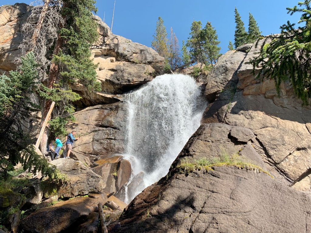
Ouzel Falls
It’s been a while since I’ve written a blog post. Summer always starts with the best intentions until the reality of the busyness of the season hits like a freight train. Not much time for writing! But, I promise, more will be on the way in the coming weeks/months. Our old blog was one of the more popular ones in the state with great tips on hiking, locations, Estes Park info, and other tidbits of life in the mountains that our loyal followers found interesting.
So I’ll kick of the late summer hiking series with a brief description of Ouzel Falls. This is a guest favorite and has been for many many years for good reason.
Getting there:
Head south out of town along the Peak to Peak Highway (Hwy 7). About 30 minutes from the lodge you’ll see a sign (smaller now than in the past, so keep watch, it comes up suddenly) marking the entrance to Wild Basin. Head down this road a short distance and enter through the small, often unmanned, entrance station. Do have you park pass handy as if it is manned you’ll need it to get in. Slowly travel down the narrow dirt road to the Wild Basin Ranger Station and the trail head for the Thunder Lake Trail. In the summer months, leave early as this is a small parking area and fills up very quickly (like by 7:00am). Today, I missed getting the last spot by one car and had to park in some overflow parking about 1/10th of a mile back down the road… this was right at 9:00am. Mid/late August is the best time to visit this area as you still have perfect summer weather but the big summer crowds are gone.
The Hike:
Prep your kit and hit the trail. As an avid trail runner I love Wild Basin as this trail starts off super gentle and gradually gets steeper as you go, with great stretches of gentler grades along the way. The first half mile or so is very gentle gaining only about 100 feet. This gives you a great opportunity to settle into a good groove and let the legs warm up a bit.
About a third of a mile in, you come to Copeland “Falls.” I put falls in parenthesis as it’s really not much more than a series of rapids and no real falls to speak of, at least in the sense that most folks are thinking when they want to see a waterfall. I think I’ve stopped here once on my own and a couple of times with my daughters, but usually bypass it without giving it a second though.
Continue on up the trail as it begins to steepen a bit. At approx.. 1.5 miles in you come to a large bridge crossing the St. Vrain River. This is a great spot to stop and take a quick breather, especially in the spring when the river is impressively powerful. Take a few deep breaths, take a sip of water, and get ready for the steeper trail ahead.
This next stretch is only about .4 or .5 mile in length, but seems longer than that as your pace will certainly slow due to the increased grade. It goes by pretty quick and soon you’ll be standing below a picturesque little cascade called Calypso Cascades. Take a minute to soak in the scene, as it’s a truly beautiful spot.
From Calypso you have just under a mile to go before you reach Ouzel Falls. The trail is relatively flat through an old burn area but then steepens and gains about 300 feet in the last half mile before the falls. Once you get to the bridge below the falls, hike up the steep social trail on the near side of the stream to the base of the actual waterfall. It’s well worth the short, steep trek. On a warm summer day, the mist is a welcome relief and there are a few good logs to sit and enjoy a snack. Make sure to get some photos and take a bit of time to really soak it all in.
To get back, just return the way you came. Right at the trail head there’s a great little stream where it’s perfect to ditch the shoes and soak your feet in the cold mountain waters! Happy Trails!
Hike Info:
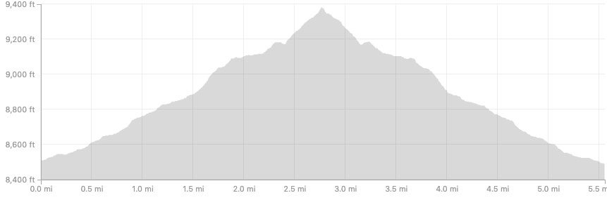
Distance: 5.55 Miles
Elevation Gain: 909 Feet
Trail Head Elevation: 8,510 Feet
Ouzel Falls Elevation: 9,380 Feet